

| << Chapter < Page | Chapter >> Page > |
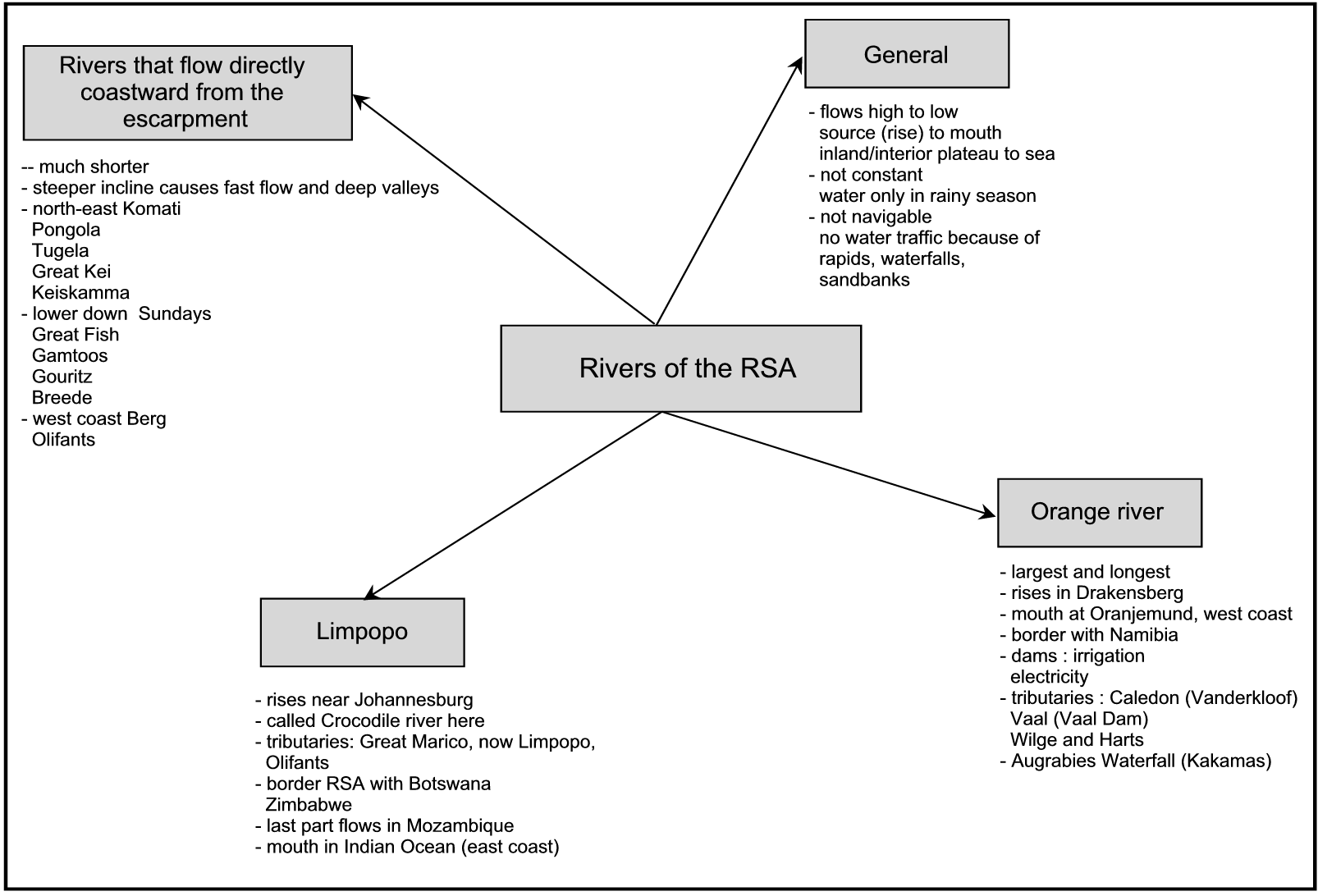
2. Rivers of the RSA
All rivers flow from a high-lying area to a low-lying area. All the rivers of the RSA rise from the interior plateau or the escarpment (watershed) and flow to the sea. Many of the rivers of the RSA are not constant , which means that they only contain water during the rainy season. The rivers of the RSA are also unsuitable for water traffic, because of the many rapids, waterfalls and sandbanks. These types of rivers are called unnavigable rivers.
The Orange River
The Orange River is the largest and longest river in South Africa. It rises in the Drakensberg in the east (near Mont-Aux-Sources) and flows westward across the full breadth of the RSA. Its mouth is at Oranjemund along the west coast. The Orange River forms quite a number of borders, of which the most important is the border between the RSA and Namibia.
The Gariep Dam was built in the upper courses of the Orange River to store water for the dry periods of the year. Thus the water is used mainly for irrigation, but the dam is also an important source of hydro-electric power.
Just to the east of the dam the first tributary, the Caledon River , in which the Vanderkloof Dam was built, joins the Orange River. Near Douglas, the second tributary, the Vaal River, which houses the Vaal Dam, joins up, and later the Wilge and Harts Rivers flow into the Vaal River. The Augrabies Waterfall is near Kakamas, which is lower down in the Orange.
The Limpopo River
The Limpopo rises near Johannesburg, where it is called the Crocodile River. Just after it is joined by the Great Marico tributary, it is called the Limpopo. Another important tributary is the Olifants River. The Limpopo first forms the border between the RSA and Botswana, and later also between the RSA and Zimbabwe. It then flows through Mozambique, where it ultimately flows into the Indian Ocean.
Rivers that flow directly coastwards from the escarpment
These rivers are much shorter and decline more sharply towards the sea. This causes them to flow rapidly in deep valleys, which makes irrigation quite difficult.
The rivers to the northeast, which rise in the Drakensberg escarpment, are the Komati, Pongola, Tugela, Great Kei and Keiskamma Rivers. Lower down there are the Sundays, Great Fish , Gamtoos, Gouritz and Breede Rivers. The Berg and Olifants Rivers flow along the west coast .
Use your atlas to identify the rivers indicated on the map.
Rivers of the RSA
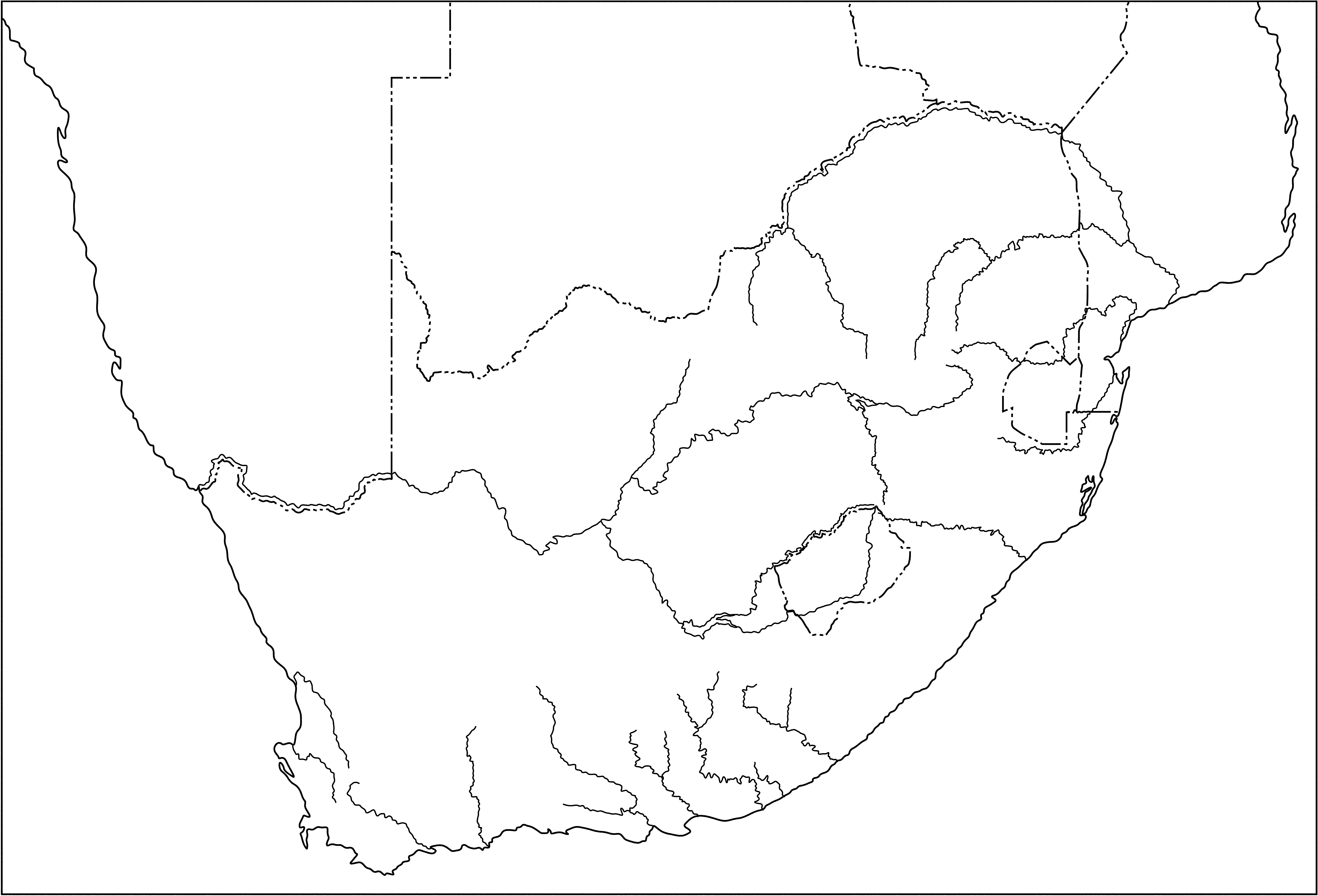
Johannesburg
| The Orange River System |
| 1. |
| 2. |
| 3. |
| 4. |
| 5. |
| 6. |
| The Limpopo River System |
| 7. |
| 8. |
| 9. |
| 10. |
| Rivers from escarpment to coastal plain |
| 11. |
| 12. |
| 13. |
| 14. |
| 15. |
| 16. |
| 17. |
| 18. |
| 19. |
| 20. |
| 21. |
| 22. |
LO 1
GEOGRAPHICAL ENQUIRY
The learner will be able to use enquiry skills to investigate geographical and environmental concepts and processes.
We know this when the learner:
LO 2
GEOGRAPHICAL KNOWLEDGE AND UNDERSTANDING
The learner will be able to demonstrate geographical and environmental knowledge and understanding.
We know this when the learner:
2.1 identifies and describes major physical features of South Africa, including those of the home province [people and places];
2.2 identifies links between natural resources and economic activities in South Africa [people and resources];
2.3 describes ways in which the physical environment influences human activity and how human activity is influenced by the physical environment [people and the environment].
Notification Switch
Would you like to follow the 'Social sciences: geography grade 5' conversation and receive update notifications?

|
|

|
|

|
|

|
|

|
|

|
|

|
|

|
|

|
|

|