<< Chapter < Page Chapter >> Page >

Geography

Grade 5

Climate and vegetation regions of south africa

Module 12

The climate of south africa: temperature

1. The topography of South Africa

  • Because the relief of a country has a major influence on the climate of the country, we must refer to it again briefly. For more information you can return to the modules on South Africa’s physical structure.
  • If you study any natural map in an atlas, it will become clear that our country lies at varying heights above sea level (altitudes). A cross-profile of the topography of the RSA looks more or less like an inverted saucer.

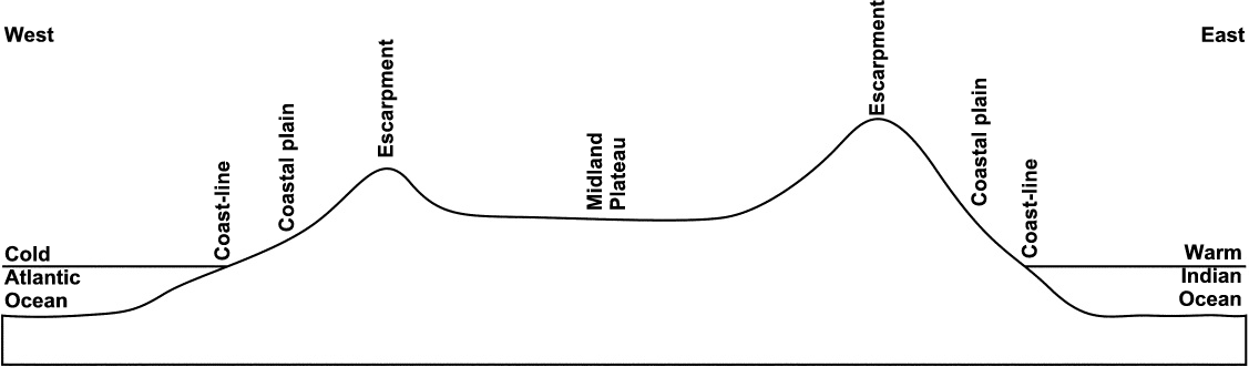
Figure 1: A cross-profile of the RSA

  • The largest part of South Africa lies high above sea level. A warm sea-current flows along the east coast and a cold sea-current along the west coast. The high mountains along the coast cut off the midland plateau. These factors strongly influence the climate of the country.

2. Factors affecting South Africa’s climate

T emperature

South Africa displays typical temperature patterns during different seasons. Few people plan a holiday on the west coast in winter, while Durban (south-east coast) has ideal holiday temperatures during winter.

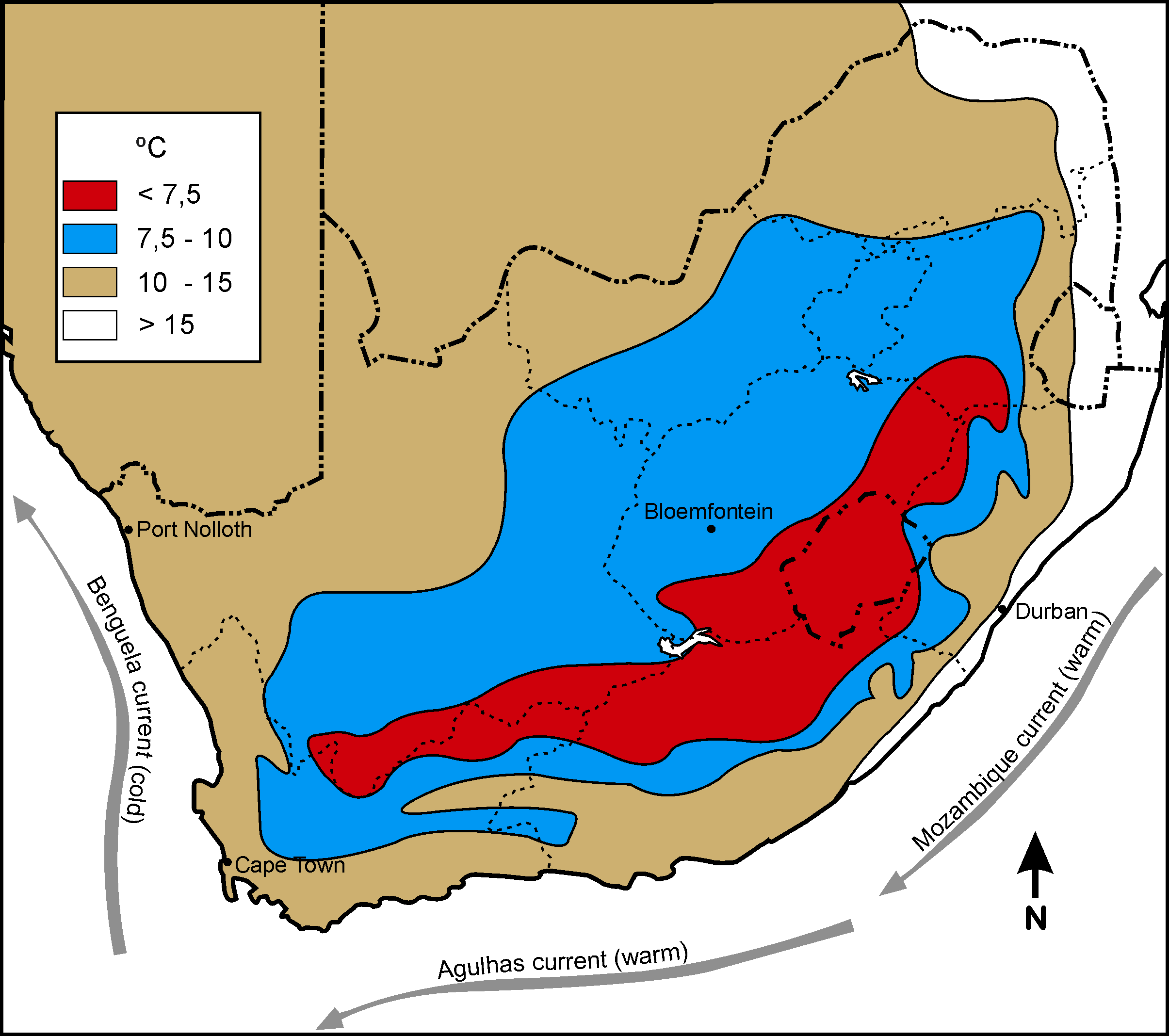
Winter temperature in South Africa
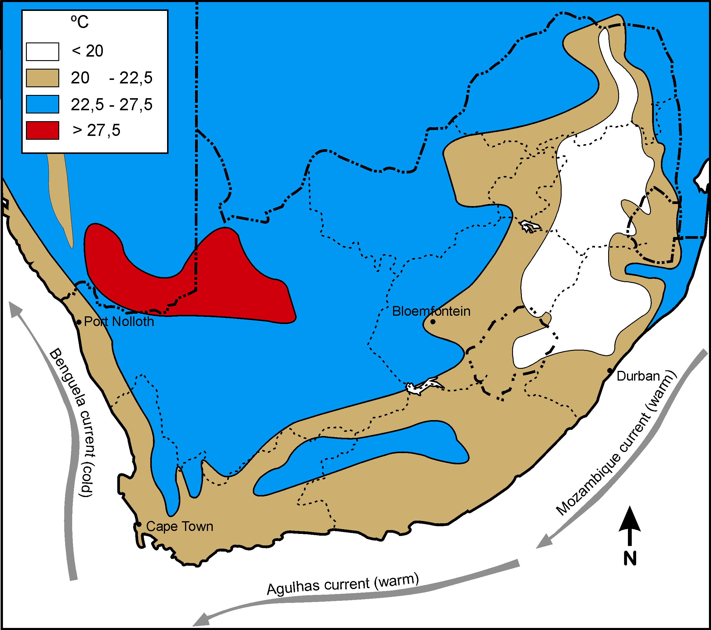
Summer temperature in South Africa

The temperature of the RSA is influenced by the following:

Latitude location

The further a region is located from the Equator (0º L), the colder it is. Places in the tropics therefore experience warmer temperatures than places at the poles.

Altitude

The higher you go above sea level, the colder it becomes. Temperature therefore drops as altitude increases. Because the RSA’s interior plateau is located high above sea level, it will be colder there than in parts along lower coastal areas. Frost is common on the interior plateau and snow occurs on the high mountains.

Sea currents

The warm Mozambique current flows southwest along the RSA’s east coast, and the cold Benguela current flows north along the west coast. Air above a cold current is cold and there is little chance of rain. With a warm current the air is warm, rises, condenses and clouds and rain occur.

Distance from the sea

The sea has a moderating effect on climate. This means that areas that are close to the sea are not too hot in summer and not too cold in winter. The temperature margin is therefore small (difference between the highest and lowest temperatures). The reason for this is that water masses are not heated as quickly through insulation as the land surfaces. However, once water has absorbed heat, it retains it for longer than land surfaces. During the day radiation of heat from the soil is high, but it is low at night.

During the day the radiation from the sea’s water is less and this results in lower temperatures than in the case of the interior. At night the earth radiates heat for longer and the coastal areas are therefore warmer at night than the interior. Use this information to do the following activities.

Activity 1:

To study the line graphs and answer the questions

[lo 1.1;1.7]

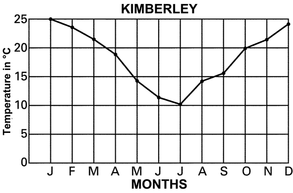
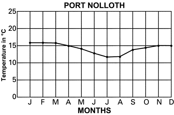
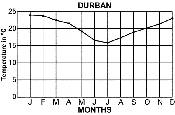
Explain why the day and night temperatures in Kimberley differ much more than those in Port Nolloth and Durban.

Why is Durban’s temperature higher than that of Port Nolloth? Use your atlas to find the places if you are unsure.

Activity 2:

To draw a line graph of the temperatures of bloemfontein and cape town

[lo 1.7]

Study the following temperatures. Find the location of the various places in an atlas if you do not know where they are located. Remember the labels and headings.

Months Jan Feb Mar Apr May Jun Jul Aug Sept Oct Nov Dec
Bloem-fontein24°S;1 400 mabove sea level 23 22 20 16 11 9 8 11 15 18 20 22
Cape Town34°S; sea level 22 22 20 18 15 14 13 14 15 17 19 20

For each place in the above table indicate the following:

  • the highest monthly temperature
  • the lowest monthly temperature
  • the temperature margin (difference between highest and lowest temperatures)
  • the average temperature

Explain the difference in temperature between the following places by referring to the factors that affect the climate of South Africa

  • Port Nolloth and Bloemfontein
  • Bloemfontein and Cape Town

Assessment

LO 1

GEOGRAPHICAL ENQUIRY

The learner will be able to use enquiry skills to investigate geographical and environmental concepts and processes.

We know this when the learner:

1.1 with guidance, selects and uses sources of useful geographical information (including graphs, maps and fieldwork outside the classroom) [finds sources];

  • distinguishes between facts and opinions [works with sources];
  • categorises information [works with sources];
  • draws sketch maps and/or plans from field observation and measurements [works with sources];

1.7 demonstrates knowledge and under-standing of the issue through projects, discussion, debate and charts [communicates the answer].

Memorandum

  • Interior – far from the temperate influence of the ocean
  • On a plateau – low winter temperature
  • Warm ocean current

Questions & Answers

it is the relatively stable flow of income
Chidubem Reply
what is circular flow of income
Divine Reply
branches of macroeconomics
SHEDRACK Reply
what is Flexible exchang rate?
poudel Reply
is gdp a reliable measurement of wealth
Atega Reply
introduction to econometrics
Husseini Reply
Hi
mostafa
hi
LEMLEM
hello
Sammol
hi
Mahesh
bi
Ruqayat
hi
Ruqayat
Hi fellas
Nyawa
hey
Sammol
hi
God
hello
Jahara
Good morning
Jorge
hi
abubakar
hi
Nmesoma
hi
Mahesh
Hi
Tom
Why is unemployment rate never zero at full employment?
Priyanka Reply
bcoz of existence of frictional unemployment in our economy.
Umashankar
what is flexible exchang rate?
poudel
due to existence of the pple with disabilities
Abdulraufu
the demand of a good rises, causing the demand for another good to fall
Rushawn Reply
is it possible to leave every good at the same level
Joseph
I don't think so. because check it, if the demand for chicken increases, people will no longer consume fish like they used to causing a fall in the demand for fish
Anuolu
is not really possible to let the value of a goods to be same at the same time.....
Salome
Suppose the inflation rate is 6%, does it mean that all the goods you purchase will cost 6% more than previous year? Provide with reasoning.
Geetha Reply
Not necessarily. To measure the inflation rate economists normally use an averaged price index of a basket of certain goods. So if you purchase goods included in the basket, you will notice that you pay 6% more, otherwise not necessarily.
Waeth
discus major problems of macroeconomics
Alii Reply
what is the problem of macroeconomics
Yoal
Economic growth Stable prices and low unemployment
Ephraim
explain inflationcause and itis degre
Miresa Reply
what is inflation
Getu
increase in general price levels
WEETO
Good day How do I calculate this question: C= 100+5yd G= 2000 T= 2000 I(planned)=200. Suppose the actual output is 3000. What is the level of planned expenditures at this level of output?
Chisomo Reply
how to calculate actual output?
Chisomo
how to calculate the equilibrium income
Beshir
Criteria for determining money supply
Thapase Reply
who we can define macroeconomics in one line
Muhammad
Aggregate demand
Mohammed
C=k100 +9y and i=k50.calculate the equilibrium level of output
Mercy Reply
Hi
Isiaka
Hi
Geli
hy
Man
👋
Bahunda
hy how are you?
Man
ys
Amisha
how are you guys
Sekou
f9 guys
Amisha
how are you guys
Sekou
ys am also fine
Amisha
fine and you guys
Geli
from Nepal
Amisha
nawalparasi district from belatari
Amisha
nd u
Amisha
I am Camara from Guinea west Africa... happy to meet you guys here
Sekou
ma management ho
Amisha
ahile becheclor ho
Amisha
hjr ktm bta ho ani k kaam grnu hunxa tw
Amisha
belatari
Amisha
1st year ho
Amisha
nd u
Amisha
ahh
Amisha
kaha biratnagar
Amisha
ys
Amisha
kina k vo
Amisha
money as unit of account means what?
Kalombe
A unit of account is something that can be used to value goods and services and make calculations
Jim
all of you please speak in English I can't understand you're language
Muhammad
I want to know how can we define macroeconomics in one line
Muhammad
it must be .9 or 0.9 no Mpc is greater than 1 Y=100+.9Y+50 Y-.9Y=150 0.1Y/0.1=150/0.1 Y=1500
Kalombe
Mercy is it clear?😋
Kalombe
hi can someone help me on this question If a negative shocks shifts the IS curve to the left, what type of policy do you suggest so as to stabilize the level of output? discuss your answer using appropriate graph.
Galge Reply
if interest rate is increased this will will reduce the level of income shifting the curve to the left ◀️
Kalombe
Got questions? Join the online conversation and get instant answers!
Jobilize.com Reply

Get Jobilize Job Search Mobile App in your pocket Now!

Get it on Google Play Download on the App Store Now


Source:  OpenStax, Social sciences: geography grade 5. OpenStax CNX. Sep 23, 2009 Download for free at http://cnx.org/content/col10986/1.2
Google Play and the Google Play logo are trademarks of Google Inc.

Notification Switch

Would you like to follow the 'Social sciences: geography grade 5' conversation and receive update notifications?

Ask