

| << Chapter < Page | Chapter >> Page > |
1. Location
The location of a place can be determined by various means:
1.1 The index of the atlas
There is an alphabetical list of place names at the back of each atlas.
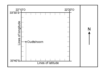
Let’s take Oudtshoorn as an example: Oudtshoorn RSA 8 - 33º 36” S, 22º 11’ E.
The number of the page on which you will find Oudtshoorn is given directly after the name Oudtshoorn.
This is followed by the latitude: 33º 36” S.
Which is followed by the longitude: 22º 11” E.
Oudtshoorn will be shown on the map at the place where these lines cross.
Example:
REMEMBER!
The latitude is ALWAYS given FIRST. As South Africa is situated in the Southern Hemisphere, the southern longitudinal line is given first, followed by the eastern latitudinal line, as South Africa also lies in the Eastern Hemisphere.
A map is divided into blocks of the same size. Blocks arranged horizontally, are designated numerically (in numbers), while the vertically arranged blocks are marked alphabetically. The letter and number of each block can then be used as a guide to locate a place.
Example:
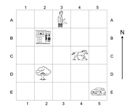
The man is in block 3A.
1. a Building
2. a Horse
3. a Tree
4. a Car :
1.1.1 Grid referencing / Coordinates
This is the method that is used to indicate location on 1:50 000 topographic maps.
Each topographic map sheet represents a portion of a degree (º).
Each degree is divided into 60 minutes (‘).
Each minute, again, is divided into 60 seconds (“).
Example:
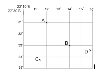
The location of A is 33º 31’ S; 22º 12’ E.
The location of B is 33º 33’ S; 22º 14’ E.
What will the location of C and D be?
REMEMBER!
There are 60 seconds (“) between two minute lines, but this is not indicated on topographic maps. These 60” have to be estimated (30”, for instance, will lie more or less in the central position between two minute lines.)
The location of C is 33º 34’ 10” S; 22º 11’ 25” E.
The location of D is 33º 33’ 30” S; 22º 15’ 50” E.
REMEMBER!
All the latitudinal lines on 1:50 000 topographic maps are Southern latitudinal lines and the higher numbers are towards the south. All the longitudinal lines are EASTERLY longitudes and their numbers increase eastwards. Latitudinal lines are always given FIRST.
| Learning Outcomes(LOs) |
| LO 1 |
| Geographical EnquiryThe learner will be able to use enquiry skills to investigate geographical and environmental concepts and processes. |
| Assessment Standards(ASs) |
| We know this when the learner: |
|
|
|
|
ACTIVITY1:
ACTIVITY 2:
ACTIVITY2:
Notification Switch
Would you like to follow the 'Geography grade 8' conversation and receive update notifications?

|
|

|
|

|
|

|
|

|
|

|
|

|
|

|
|

|
|

|